Over Last 7 Days, 8 Earthquakes Rattle Eastern United States
[ad_1]
According to USGS, over the last 7 days, 8 earthquakes have rattled portions of the eastern United States and Canada. The strongest of the weak earthquakes was a magnitude 2.1 event which struck on Thursday night in Kentucky. Due to the intensity of these earthquakes, or lack thereof, there were no reports of damage or injuries.
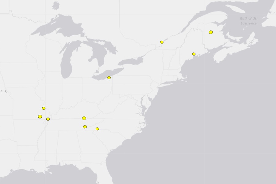
The first of the seven day period to strike was just east-northeast of Brevard, North Carolina. The magnitude 1.8 earthquake was shallow and struck from a depth of only 0.4 km.
Seven hours after the first, another weak magnitude 1.8 earthquake struck the small town of Swanville, Maine. Striking from a depth of 7.4 km, this quake wasn’t far from Bar Harbor.
The third earthquake hit just east of Niota, Tennessee. It struck from a depth of 10 km.
The fourth earthquake struck near Madison, Ohio, where there’s been a persistent rumble of earthquake activity in recent weeks. The magnitude 1.7 earthquake struck from a depth of 5 km, not far from where the other epicenters of recent earthquakes struck.
The fifth earthquake struck the Quebec Province of Canada near the town of L’Epiphanie, north of Montreal. The magnitude 1.8 event had a depth of 8.4 km.
The sixth earthquake struck very close to where the third quake struck, near Niota and Madisonville. This magnitude 1.5 event had a depth of 13.9 km.
The seventh earthquake struck northeast of Maine in Miramichi, Canada. This magnitude 2.0 event struck from a depth of 5 km.
The eight earthquake, the strongest of the bunch, struck southwest of Stearns, Kentucky. The magnitude 2.1 earthquake had a depth of 25.4 km.
In addition to these 8 earthquakes, there were also 4 earthquakes over the last 7 days in the hyperactive New Madrid Seismic Zone (NMSZ) near the Mississippi River. All 4 of these earthquakes were located in Missouri. The first, a magnitude 1.9, struck on the night of February 18 near Weingarten from a depth of 5.1 km. The next two happened at the same spot in Marston, 3 hours apart on the afternoon of the 19th; the first was a magnitude 1.5 from a depth of 7.4 km while the second was a magnitude 1.6 from a depth of 7.9 km. The last and strongest struck Grandin from a depth of 15.2 km; it was a magnitude 2.7 event.
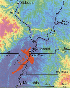
While the US West Coast is well known for its seismic faults and potent quakes, many aren’t aware that one of the largest quakes to strike the country actually occurred near the Mississippi River. On December 16, 1811, at roughly 2:15am, a powerful 8.1 quake rocked northeast Arkansas in what is now known as the New Madrid Seismic Zone. The earthquake was felt over much of the eastern United States, shaking people out of bed in places like New York City, Washington, DC, and Charleston, South Carolina. The ground shook for an unbelievably long 1-3 minutes in areas hit hard by the quake, such as Nashville, Tennessee and Louisville, Kentucky. Ground movements were so violent near the epicenter that liquefaction of the ground was observed, with dirt and water thrown into the air by tens of feet. President James Madison and his wife Dolly felt the quake in the White House while church bells rang in Boston due to the shaking there.
But the quakes didn’t end there. From December 16, 1811 through to March of 1812, there were over 2,000 earthquakes reported in the central Midwest with 6,000-10,000 earthquakes located in the “Bootheel” of Missouri where the New Madid Seismic Zone is centered.
The second principal shock, a magnitude 7.8, occurred in Missouri weeks later on January 23, 1812, and the third, a 8.8, struck on February 7, 1812, along the Reelfoot fault in Missouri and Tennessee.
The main earthquakes and the intense aftershocks created significant damage and some loss of life, although lack of scientific tools and news gathering of that era weren’t able to capture the full magnitude of what had actually happened. Beyond shaking, the quakes also were responsible for triggering unusual natural phenomena in the area: earthquake lights, seismically heated water, and earthquake smog.
Residents in the Mississippi Valley reported they saw lights flashing from the ground. Scientists believe this phenomena was “seismoluminescence”; this light is generated when quartz crystals in the ground are squeezed. The “earthquake lights” were triggered during the primary quakes and strong aftershocks.
Water thrown up into the air from the ground, or the nearby Mississippi River, was also unusually warm. Scientists speculate that intense shaking and the resulting friction led to the water to heat, similar to the way a microwave oven stimulates molecules to shake and generate heat. Other scientists believe as the quartz crystals were squeezed, the light they emit also helped warm the water.
During the strong quakes, the skies turned so dark that residents claimed lit lamps didn’t help illuminate the area; they also said the air smelled bad and was hard to breathe. Scientists speculate this “earthquake smog” was caused by dust particles rising up from the surface, combining with the eruption of warm water molecules into the cold winter air. The result was a steamy, dusty cloud that cloaked the areas dealing with the quake.
The February earthquake was so intense that boaters on the Mississippi River reported that the flow of the water there reversed for several hours.
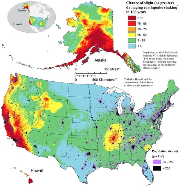
The area remains seismically active and scientists believe another strong quake will impact the region again at some point in the future. Unfortunately, the science isn’t mature enough to tell whether that threat will arrive next week or in 50 years. Either way, with the population of New Madrid Seismic Zone huge compared to the sparsely populated area of the early 1800s, and tens of millions more living in an area that would experience significant ground shaking, there could be a very significant loss of life and property when another major quake strikes here again in the future.
[ad_2]