Storm Prediction Center Mesoscale Discussion 243
[ad_1]
|
|
| Mesoscale Discussion 243 | |
|
|
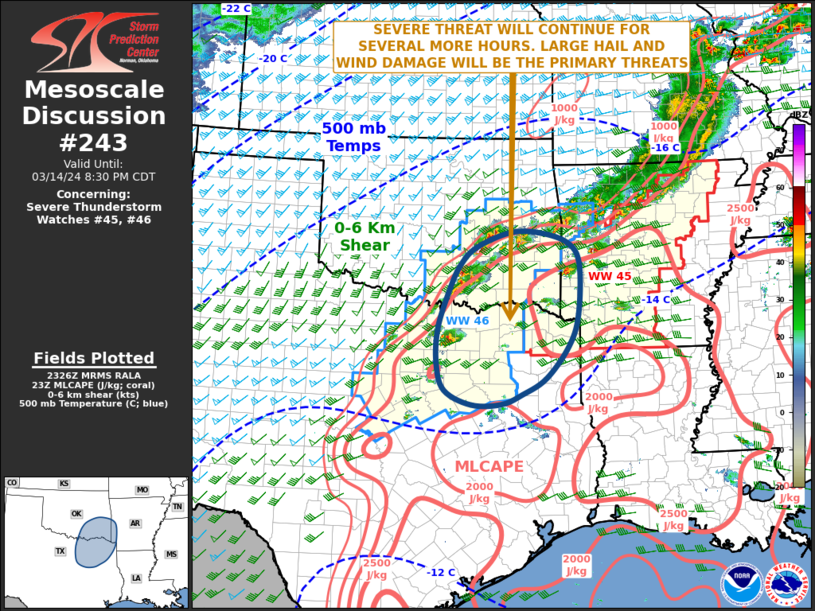
   Mesoscale Discussion 0243
   NWS Storm Prediction Center Norman OK
   0628 PM CDT Thu Mar 14 2024

   Areas affected...Southeast Oklahoma...Far Southwest
   Arkansas...Northeast Texas

   Concerning...Severe Thunderstorm Watch 45...46...

   Valid 142328Z - 150130Z

   The severe weather threat for Severe Thunderstorm Watch 45, 46
   continues.

   SUMMARY...Strong to severe thunderstorms, associated with large hail
   and wind damage, will continue this evening from southeast Oklahoma
   into parts of northeast Texas. The threat should eventually affect
   far southwest Arkansas.

   DISCUSSION...The latest high-resolution radar from Fort Smith,
   Arkansas shows several supercells and multiple short bowing segments
   across southeast Oklahoma, with isolated storms developing across
   northeast Texas. These storms are located ahead of a cold front in a
   moist airmass, where the RAP is estimating MLCAPE in the 1500 to
   2500 J/kg range. In addition, a plume of steep mid-level lapse rates
   exceeding 8 C/km is located across much of the area. This
   thermodynamic environment combined with moderate deep-layer shear
   will be favorable for supercells with large hail. The strongest of
   storms may be capable of producing hailstones greater than 2 inches
   in diameter. As cell coverage increases this evening, an organized
   line segment with wind-damage potential could also develop.

   ..Broyles.. 03/14/2024

   ...Please see www.spc.noaa.gov for graphic product...

   ATTN...WFO...LZK...SHV...TSA...FWD...OUN...

   LAT...LON   31969581 32159534 32459480 33069428 33679406 34639404
               35039431 35229496 35219562 34939638 34609674 34189697
               33419724 32759727 32239708 31959648 31969581
|
|
|
Top/All Mesoscale Discussions/Forecast Products/Home |
|
[ad_2]