Storm Prediction Center Mesoscale Discussion 258
[ad_1]
|
|
| Mesoscale Discussion 258 | |
|
|
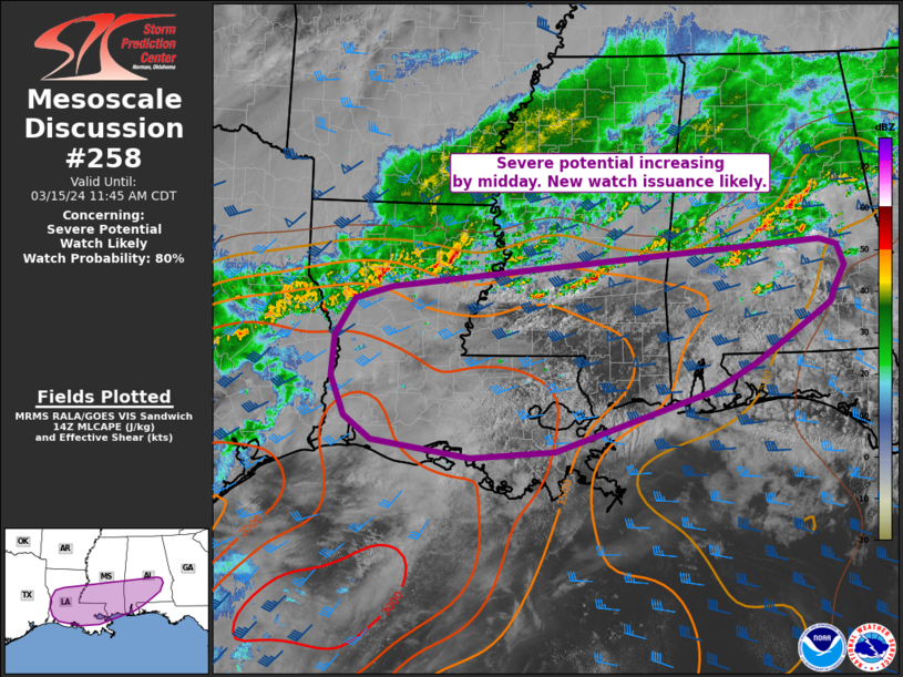
   Mesoscale Discussion 0258
   NWS Storm Prediction Center Norman OK
   0945 AM CDT Fri Mar 15 2024

   Areas affected...portions of central/southern LA...southern MS/AL

   Concerning...Severe potential...Watch likely

   Valid 151445Z - 151645Z

   Probability of Watch Issuance...80 percent

   SUMMARY...Severe potential is increasing across parts of Louisiana
   into southern Mississippi late this morning. Large hail and damaging
   gusts, along with a tornado or two will be possible across the MCD
   area through the afternoon. A watch will likely be needed within the
   next couple of hours.

   DISCUSSION...Occasionally strong storms have been ongoing this
   morning across central Alabama across WW 51. This activity will
   persist and local watch extensions may be needed across the
   Birmingham forecast area in the short term to address locally
   damaging gust and hail concerns.

   To the south/southwest across LA into southern MS, stronger heating
   is noted with temperatures approaching the mid 70s amid 70-73 F
   dewpoints. Steep midlevel lapse rates atop this moist boundary-layer
   are already supporting moderate to strong destabilization. Visible
   satellite imagery depicts agitated cumulus along/ahead of the
   southeast-sagging outflow. Furthermore, water vapor imagery
   indicates a compact shortwave trough over east TX. This is expected
   to overspread LA/MS this afternoon, providing large-scale ascent
   across the very moist and unstable boundary-layer. Morning CAMs
   depict increasing storm coverage by midday and this seems reasonable
   given short term trends in observational data this morning. Vertical
   shear will be somewhat marginal initially, but increasing through
   the day. Supercell storms capable of large hail and damaging gusts
   will be the main concern. However, enlarged and favorably curved
   low-level hodographs are noted in forecast soundings, and a couple
   tornadoes will be possible. A new watch will likely be needed for
   portions of LA into parts of southern MS/AL within the next 1-2
   hours.

   ..Leitman/Goss.. 03/15/2024

   ...Please see www.spc.noaa.gov for graphic product...

   ATTN...WFO...TAE...BMX...MOB...JAN...LIX...LCH...SHV...

   LAT...LON   31668589 31308641 30858710 30508774 29719017 29639148
               29859300 30179343 30699363 31239360 31729329 31909270
               32508605 32418578 32148567 31858582 31668589
|
|
|
Top/All Mesoscale Discussions/Forecast Products/Home |
|
[ad_2]