Storm Prediction Center Mesoscale Discussion 262
[ad_1]
|
|
| Mesoscale Discussion 262 | |
|
|
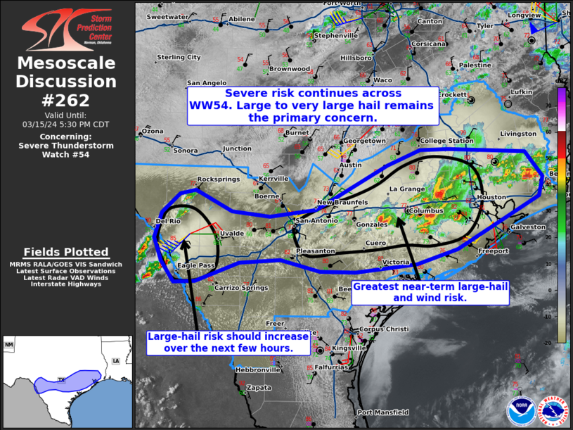
Mesoscale Discussion 0262 NWS Storm Prediction Center Norman OK 0354 PM CDT Fri Mar 15 2024 Areas affected...Portions of south-central and southeast Texas Concerning...Severe Thunderstorm Watch 54... Valid 152054Z - 152230Z The severe weather threat for Severe Thunderstorm Watch 54 continues. SUMMARY...The severe-storm risk continues across Severe Thunderstorm Watch 54. Large to very large hail remains the primary concern. DISCUSSION...Supercell clusters continue to evolve/intensify between San Antonio and Houston TX this afternoon, generally focused along the outflow-modified cold front draped across the area. The environment remains favorable for large to very large hail production (possibly increasing to near 2 to 3-inch diameter) with these supercells, given fairly weak sub-freezing level shear/buoyancy and favorable instability and cloud-layer shear through the hail-growth zone. So far, 1.75 inch hail and wind damage has been reported with this activity. In addition to the large-hail risk, severe-gust potential should also increase owing to localized upscale growth into larger supercell clusters and bowing segments. However, the increasing storm coverage could also lead to destructive interference with time, especially northwest of the Houston area. Farther west, two discrete supercells are ongoing west-northwest of Eagle Pass TX (across the International border). While these storms are largely anchored to the higher terrain, east-southeast right-mover and north-northeast left-mover storm motion vectors could allow this activity to spread across the border with time. Continued pre-convective heating/destabilization amid favorable vertical shear should support the maintenance of this activity into TX, with the primary risk being very large hail. ..Weinman.. 03/15/2024 ...Please see www.spc.noaa.gov for graphic product... ATTN...WFO...LCH...HGX...CRP...EWX... LAT...LON 28560016 28540053 28840076 29190089 29580077 29860045 29920018 29629956 29549891 29659810 30339688 30569630 30579582 30509448 30139419 29849426 29069567 28849637 28729742 28739804 28899871 28859942 28560016 |
|
|
Top/All Mesoscale Discussions/Forecast Products/Home |
|
[ad_2]