Storm Prediction Center Mesoscale Discussion 263
[ad_1]
|
|
| Mesoscale Discussion 263 | |
|
|
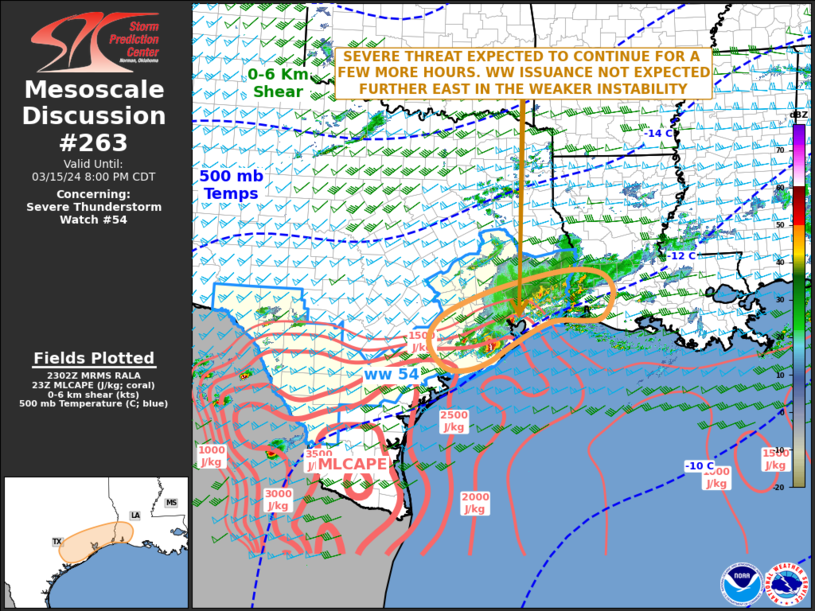
   Mesoscale Discussion 0263
   NWS Storm Prediction Center Norman OK
   0605 PM CDT Fri Mar 15 2024

   Areas affected...Southeast Texas...Southwest Louisiana

   Concerning...Severe Thunderstorm Watch 54...

   Valid 152305Z - 160100Z

   The severe weather threat for Severe Thunderstorm Watch 54
   continues.

   SUMMARY...A severe threat is expected to continue across parts of
   southeast Texas and far southwest Louisiana for a couple more hours.
   Isolated large hail and wind damage will be the main threats. The
   severe threat may spread eastward further into southwest Louisiana,
   but is expected to be too marginal for additional weather watch
   issuance.

   DISCUSSION...The latest hi-resolution radar imagery from Houston
   shows a cluster of strong thunderstorms near the Texas-Louisiana
   state line, with additional more discrete storms to the southwest of
   Houston. The storms are located along the eastern edge of a
   moderately unstable airmass where the RAP has MLCAPE in the 1500 to
   2500 J/kg range. In addition, the WSR-88D VWP at Houston and Lake
   Charles have 0-6 km shear generally in the 55 to 65 knot range. This
   environment should support a severe threat for a couple more hours,
   with a potential for wind damage and isolated large hail. On radar,
   an outflow boundary is moving southward off the coast of southwest
   Louisiana. The airmass behind the boundary is more stable. As the
   stronger cells move eastward into this relatively weak instability
   across southwest Louisiana, the severe threat is expected to become
   marginal. For this reason, watch issuance is not planned to the east
   of WW 54.

   ..Broyles.. 03/15/2024

   ...Please see www.spc.noaa.gov for graphic product...

   ATTN...WFO...LCH...HGX...EWX...

   LAT...LON   30419530 30759385 30729304 30449271 30079276 29809298
               29769337 29759408 29309496 28979547 28809597 28819640
               29029669 29359686 29709673 30019629 30419530
|
|
|
Top/All Mesoscale Discussions/Forecast Products/Home |
|
[ad_2]