Storm Prediction Center Mesoscale Discussion 273
[ad_1]
|
|
| Mesoscale Discussion 273 | |
|
|
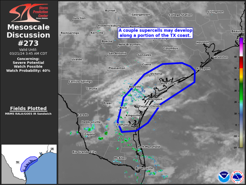
   Mesoscale Discussion 0273
   NWS Storm Prediction Center Norman OK
   0142 AM CDT Thu Mar 21 2024

   Areas affected...Middle TX Gulf Coast

   Concerning...Severe potential...Watch possible

   Valid 210642Z - 210845Z

   Probability of Watch Issuance...40 percent

   SUMMARY...A couple supercells may develop over the Middle Texas Gulf
   Coast, with more probable supercell development in the adjacent
   offshore waters of the western Gulf through the pre-dawn hours.
   Isolated large hail should be the primary threat over land.

   DISCUSSION...Weak mid-level convection persists across parts of Deep
   South TX within a corridor of modest warm theta-e advection. Bulk of
   evening guidance suggest this activity will deepen into storms and
   intensify during the next few hours by about 09Z. This appears to be
   on-track per time-series of VWP data from BRO showing some increase
   in 1-2 km flow over the past couple hours and the CRP VWP showing a
   similar trend in the past 30 minutes. With upper 60s surface dew
   points as far north as CRP, adequate buoyancy will be present once
   storms initiate. The bulk of the development should occur near and
   to the north of the modest surface-based instability plume, yielding
   convection becoming increasingly elevated with northeast extent
   along the coastal plain. Ample deep-layer shear and steep mid-level
   lapse rates should support potential for a couple supercells capable
   of large hail. The bulk of longer-lived, more intense supercells
   should be confined off the coast from the Corpus Christi to
   Matagorda Bay vicinity.

   ..Grams/Thompson.. 03/21/2024

   ...Please see www.spc.noaa.gov for graphic product...

   ATTN...WFO...HGX...CRP...BRO...

   LAT...LON   28849719 29169655 29209586 29089557 28949540 28599542
               27929661 27359705 27109746 27079795 27379810 28129791
               28849719
|
|
|
Top/All Mesoscale Discussions/Forecast Products/Home |
|
[ad_2]