Storm Prediction Center Mesoscale Discussion 279
[ad_1]
|
|
| Mesoscale Discussion 279 | |
|
|
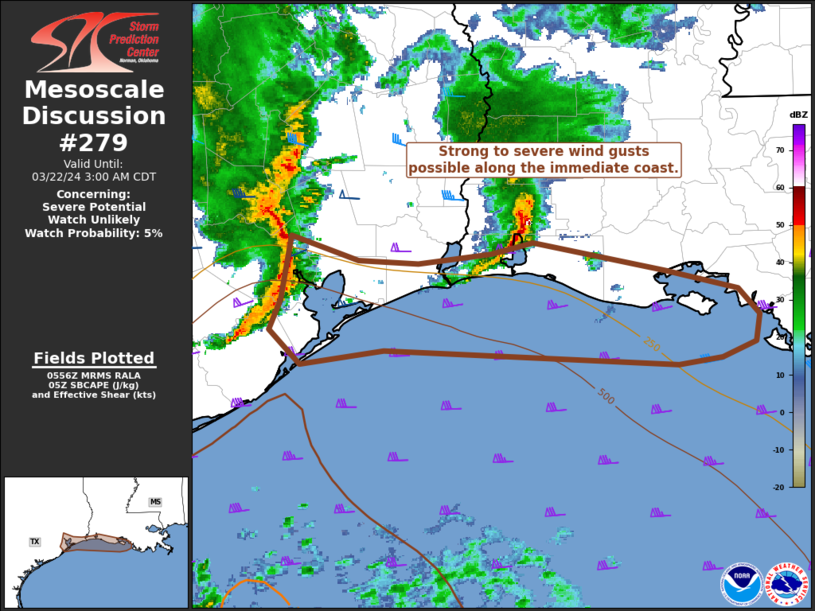
   Mesoscale Discussion 0279
   NWS Storm Prediction Center Norman OK
   1259 AM CDT Fri Mar 22 2024

   Areas affected...Immediate coast of southeast TX and southwest LA

   Concerning...Severe potential...Watch unlikely

   Valid 220559Z - 220800Z

   Probability of Watch Issuance...5 percent

   SUMMARY...A rather confined corridor of strong to severe wind gusts
   from 55-70 mph will be possible along the immediate coast of
   southeast Texas into southwest Louisiana through the pre-dawn hours.
   A watch is not expected given the extremely limited spatial extent
   of the threat over land.

   DISCUSSION...A small MCS with an embedded bowing structure will
   likely persist eastward over the next several hours along a portion
   of the northwest Gulf Coast. The northern part of this bow is
   elevated, with the southern part crossing into the northern edge of
   surface-based instability across the south Houston metro/Galveston
   Bay area where surface dew points are in the mid 60s. This bowing
   MCS has a history of 40-45 kt wind gusts across the western Houston
   Metro Area. Convective outflow from a weaker thunderstorm cluster
   over the Lake Charles area may aid in intensifying the bowing
   structure amid a low-level vorticity-rich environment, a scenario
   generally supported by evening CAM guidance. The apex of the
   slightly elevated bow may hug the immediate coastline through the
   pre-dawn hours with stronger gusts/waterspouts likely offshore.

   ..Grams/Edwards.. 03/22/2024

   ...Please see www.spc.noaa.gov for graphic product...

   ATTN...WFO...LCH...HGX...

   LAT...LON   30039511 29859457 29849410 29909352 29999318 29789211
               29669154 29479136 29299140 29179166 29139201 29229437
               29139504 29379529 29589519 30039511
|
|
|
Top/All Mesoscale Discussions/Forecast Products/Home |
|
[ad_2]