Storm Prediction Center Mesoscale Discussion 286
[ad_1]
|
|
| Mesoscale Discussion 286 | |
|
|
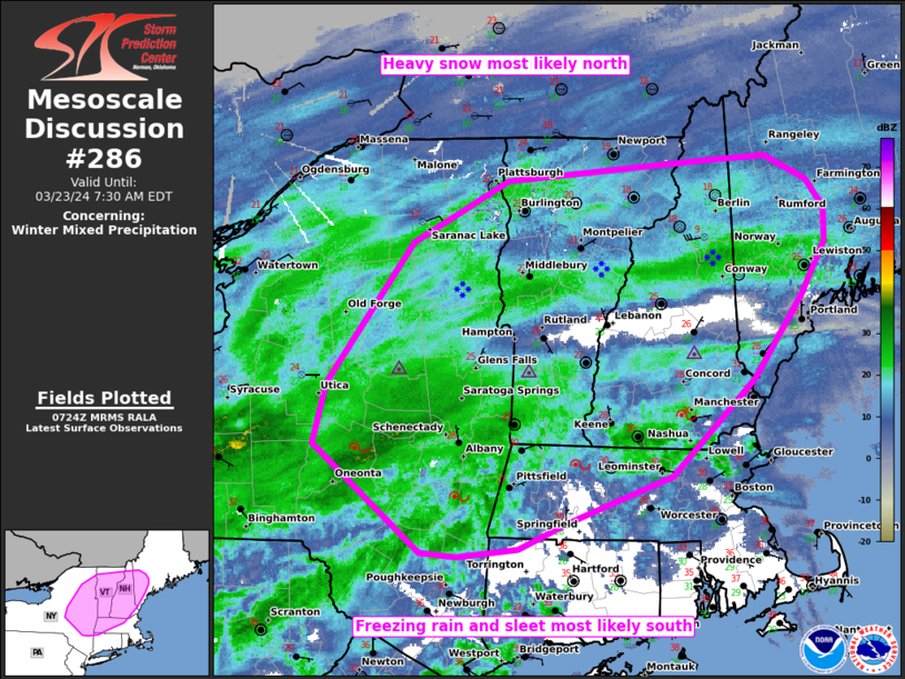
   Mesoscale Discussion 0286
   NWS Storm Prediction Center Norman OK
   0227 AM CDT Sat Mar 23 2024

   Areas affected...Parts of NY into New England

   Concerning...Winter mixed precipitation

   Valid 230727Z - 231130Z

   SUMMARY...A mix of heavy snow, sleet, and freezing rain will
   continue to spread east-northeast from parts of southern/eastern New
   York into New England through sunrise. Heavy snow rates of 1-1.5
   in/hr will be most probable in a band along the northern periphery
   of the mixed transition zone.

   DISCUSSION...An extensive swath of mixed winter precip is ongoing
   across southern to eastern NY into parts of southern VT/NH. This has
   been aided by strong low-level warm theta-e advection amid a 50-60
   kt low-level jet per ENX/BGM VWP data. Low-level warming has again
   been faster up the Hudson Valley than indicated by evening model
   guidance with prior 1"/hr snowfall rates at ALB transitioning to
   mixed freezing rain/sleet during the past hour. Based on recent
   radar trends, this mixed phase should be the dominant precip type as
   it gradually expands east-northeast into parts of MA and southern
   VT/NH in the next few hours. Precipitation rates from 0.04-0.12
   in/hr should be expected based on upstream measurements/guidance.
   Heavier snowfall rates should still occur just to the
   north-northeast of the transition zone, with rates of 1-1.5 in/hr
   becoming increasingly probable across parts of northern VT/NH into a
   part of southwest ME through sunrise.

   ..Grams.. 03/23/2024

   ...Please see www.spc.noaa.gov for graphic product...

   ATTN...WFO...GYX...BOX...BTV...ALY...BGM...

   LAT...LON   43177514 44237427 44687330 44847126 44877067 44687024
               44487007 44227007 43847030 43227079 42497163 42167269
               41957319 41907382 41937419 42737528 43177514
|
|
|
Top/All Mesoscale Discussions/Forecast Products/Home |
|
[ad_2]