Storm Prediction Center Mesoscale Discussion 294
[ad_1]
|
|
| Mesoscale Discussion 294 | |

|
|
   Mesoscale Discussion 0294
   NWS Storm Prediction Center Norman OK
   0437 PM CDT Sun Mar 24 2024

   Areas affected...Western Kansas...Western Oklahoma...Northwest Texas

   Concerning...Severe Thunderstorm Watch 59...

   Valid 242137Z - 242330Z

   The severe weather threat for Severe Thunderstorm Watch 59
   continues.

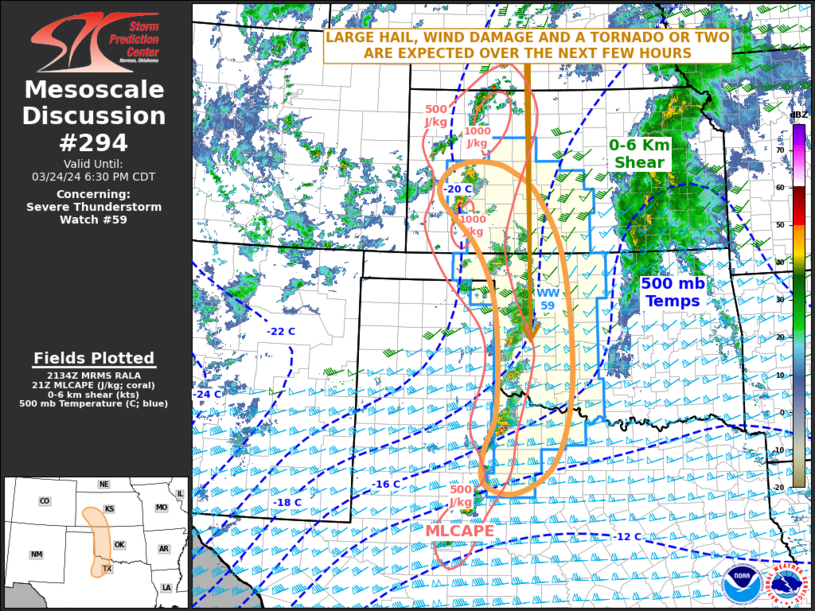
   SUMMARY...Large hail, wind damage and an isolated tornado threat are
   expected over the next few hours, as storms move eastward through WW
   59 late this afternoon into early evening.

   DISCUSSION...The latest surface analysis shows a 987 mb low over far
   southeast Colorado with a dryline extending southward from near the
   low along the Texas-Oklahoma state line and into northwest Texas.
   Strong to severe thunderstorms are ongoing just to the east of the
   dryline form southwest Kansas into western Oklahoma and northwest
   Texas. The airmass east of the dryline is weakly unstable, with
   MLCAPE estimated by the RAP in the 500 to 1000 J/kg range. The
   WSR-88D VWP at Frederick has 0-6 km shear near 60 knots, with some
   veering with height in the lowest 2 km. The strong deep-layer shear
   is evident along most of the dryline due to the exit region of an
   approaching mid-level jet. As this feature moves across the southern
   and central Plains early this evening, lift and shear will support
   supercell development. Although large hail and wind damage will be
   the primary threats, a brief tornado or two could occur with the
   stronger rotating storms.

   ..Broyles.. 03/24/2024

   ...Please see www.spc.noaa.gov for graphic product...

   ATTN...WFO...FWD...OUN...DDC...SJT...GLD...LUB...AMA...

   LAT...LON   35979997 34159994 33320022 32760020 32599949 33179863
               34659825 36879843 38059900 38509959 38670007 38650070
               38430116 37980124 37080041 35979997
|
|
|
Top/All Mesoscale Discussions/Forecast Products/Home |
|
[ad_2]


