Storm Prediction Center Mesoscale Discussion 308
[ad_1]
|
|
| Mesoscale Discussion 308 | |
|
|
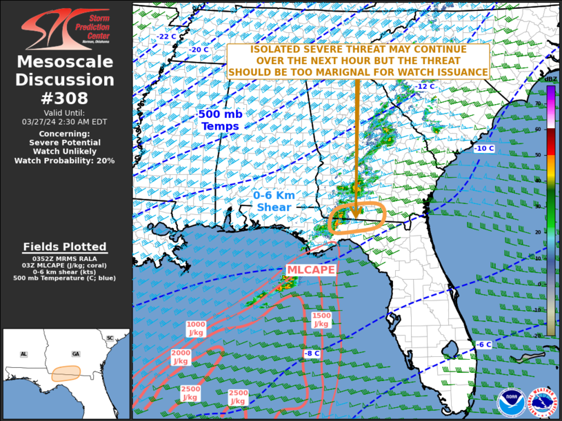
   Mesoscale Discussion 0308
   NWS Storm Prediction Center Norman OK
   1055 PM CDT Tue Mar 26 2024

   Areas affected...Eastern Florida Panhandle...Far Southern Georgia

   Concerning...Severe potential...Watch unlikely

   Valid 270355Z - 270630Z

   Probability of Watch Issuance...20 percent

   SUMMARY...An isolated severe threat may continue for another hour or
   two across parts of the eastern Florida Panhandle and far southern
   Georgia. The threat is expected to be marginal and weather watch
   issuance is not expected.

   DISCUSSION...The latest KTLH high-resolution radar shows a small
   cluster of thunderstorms, with one distinct rotating cell, near the
   Florida-Georgia state line to the northwest of Tallahassee. This
   cluster is located in a moist but weakly unstable airmass, where
   surface dewpoints are in the mid 60s F and MLCAPE is estimated by
   the RAP near 250 J/kg. The WSR-88D VWP in far southern Georgia has
   0-6 km shear near 45 knots, and 0-3km storm-relative helicity around
   270 m2/s2. This may be enough to continue an isolated severe threat
   over the next hour, as storms move eastward across the eastern
   Florida Panhandle. Marginally severe winds and hail will be the
   primary threats. Poor lapse rates are expected to limit the overall
   severe potential.

   ..Broyles/Goss.. 03/27/2024

   ...Please see www.spc.noaa.gov for graphic product...

   ATTN...WFO...JAX...TAE...

   LAT...LON   30478306 30318388 30298451 30498466 30878453 31068412
               31128313 30868285 30478306
|
|
|
Top/All Mesoscale Discussions/Forecast Products/Home |
|
[ad_2]