Storm Prediction Center Mesoscale Discussion 311
[ad_1]
|
|
| Mesoscale Discussion 311 | |
|
|
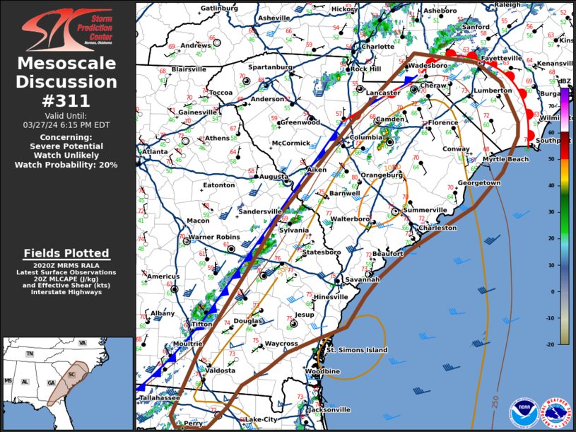
   Mesoscale Discussion 0311
   NWS Storm Prediction Center Norman OK
   0322 PM CDT Wed Mar 27 2024

   Areas affected...northern FLORIDA Peninsula...southeastern
   Georgia...eastern South Carolina...far southern North Carolina

   Concerning...Severe potential...Watch unlikely

   Valid 272022Z - 272215Z

   Probability of Watch Issuance...20 percent

   SUMMARY...Thunderstorm coverage will increase this afternoon with
   potential for instances of severe hail and wind.

   DISCUSSION...Thunderstorm development has begun in eastern Georgia
   near a surface boundary that extends from the Carolinas southward
   into the eastern Florida Panhandle. CAMs continue to suggest this
   thunderstorm activity will increase into the afternoon, with
   scattered thunderstorms expected across much of the region.
   Afternoon heating has been slow, given mid-to upper level cloud
   cover and slow eroding of stable air behind morning convection.
   Surface objective analysis indicates MLCIN has weakened with around
   500 J/kg MLCAPE across South Carolina into Georgia ahead of the
   boundary. This trend is further confirmed by thunderstorm
   development on radar.

   Currently, deep layer shear is strongest across the northern Florida
   Peninsula into southern Georgia. As the front shifts eastward this
   afternoon, stronger mid-level flow will spread northward, with deep
   layer shear increasing to the north as a result. This will support
   potential for a few more robust thunderstorms with potential for
   damaging winds and large hail. Given the slow air mass recovery and
   potential for messy storm mode with multi-cell clusters, a watch is
   unlikely to be needed this afternoon.

   ..Thornton/Hart.. 03/27/2024

   ...Please see www.spc.noaa.gov for graphic product...

   ATTN...WFO...RAH...ILM...CHS...CAE...GSP...JAX...FFC...TAE...

   LAT...LON   31138337 32258262 32988215 34258099 35118004 35207994
               35057892 34787854 34447836 34237827 34057827 33567853
               33117900 32538007 32188051 31928076 31518105 31358147
               31158197 30938228 30708268 30408289 30138320 30128368
               30278377 31138337
|
|
|
Top/All Mesoscale Discussions/Forecast Products/Home |
|
[ad_2]