Storm Prediction Center Mesoscale Discussion 312
[ad_1]
|
|
| Mesoscale Discussion 312 | |
|
|
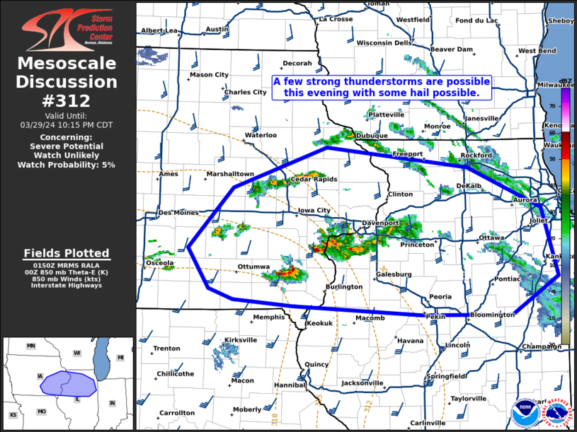
   Mesoscale Discussion 0312
   NWS Storm Prediction Center Norman OK
   0852 PM CDT Fri Mar 29 2024

   Areas affected...eastern iowa and northern Illinois

   Concerning...Severe potential...Watch unlikely

   Valid 300152Z - 300315Z

   Probability of Watch Issuance...5 percent

   SUMMARY...A few strong thunderstorms are possible this evening with
   some hail possible.

   DISCUSSION...A few strong thunderstorms are possible this evening
   from eastern Iowa into northern Illinois. Instability was quite
   limited on the 00Z DVN RAOB. However, continued warm air advection
   has likely increased instability and moistened the column between
   850 and 700mb over the past few hours. Therefore, despite the
   minimal instability, the moderate isentropic ascent associated with
   a ~40 knot low-level jet has proven sufficient for storms in the
   region. Given the strong unidirectional shear in the cloud-bearing
   layer, a few stronger storms with rotating updrafts are possible.
   Some hail to near 1 inch is possible, but expect the majority of
   hail to remain sub-severe. Isentropic ascent is expected to weaken
   in the next few hours as 850-700mb flow veers. This should bring an
   end to the marginal hail threat by late evening.

   ..Bentley/Goss.. 03/30/2024

   ...Please see www.spc.noaa.gov for graphic product...

   ATTN...WFO...LOT...ILX...DVN...DMX...

   LAT...LON   41279313 41959246 42419107 42198898 41728788 40968764
               40528833 40548968 40639156 40719245 40829282 41279313
|
|
|
Top/All Mesoscale Discussions/Forecast Products/Home |
|
[ad_2]