Note:
The expiration time in the watch graphic is amended if the watch is
replaced, cancelled or extended.
Note: Click for Watch Status Reports.
SEL1
URGENT - IMMEDIATE BROADCAST REQUESTED
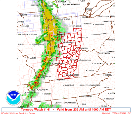
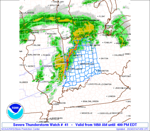
Severe Thunderstorm Watch Number 41
NWS Storm Prediction Center Norman OK
1050 AM EDT Thu Mar 14 2024
The NWS Storm Prediction Center has issued a
* Severe Thunderstorm Watch for portions of
much of Indiana
far northern Kentucky
parts of western Ohio
* Effective this Thursday morning and afternoon from 1050 AM
until 400 PM EDT.
* Primary threats include...
Scattered damaging wind gusts to 70 mph likely
Scattered large hail and isolated very large hail events to 2
inches in diameter possible
A tornado or two possible
SUMMARY...A broken band of thunderstorms is expected to continue
intensifying this morning and into this afternoon, as it moves
across Indiana and vicinity. Large hail and damaging winds will be
possible, along with potential for a couple of brief tornadoes
associated with stronger cells within the broader line of storms.
The severe thunderstorm watch area is approximately along and 70
statute miles east and west of a line from 60 miles north northwest
of Muncie IN to 50 miles south of Bloomington IN. For a complete
depiction of the watch see the associated watch outline update
(WOUS64 KWNS WOU1).
PRECAUTIONARY/PREPAREDNESS ACTIONS...
REMEMBER...A Severe Thunderstorm Watch means conditions are
favorable for severe thunderstorms in and close to the watch area.
Persons in these areas should be on the lookout for threatening
weather conditions and listen for later statements and possible
warnings. Severe thunderstorms can and occasionally do produce
tornadoes.
&&
OTHER WATCH INFORMATION...CONTINUE...WW 39...WW 40...
AVIATION...A few severe thunderstorms with hail surface and aloft to
2 inches. Extreme turbulence and surface wind gusts to 60 knots. A
few cumulonimbi with maximum tops to 450. Mean storm motion vector
24040.
...Goss
   SEL1

   URGENT - IMMEDIATE BROADCAST REQUESTED
   Severe Thunderstorm Watch Number 41
   NWS Storm Prediction Center Norman OK
   1050 AM EDT Thu Mar 14 2024

   The NWS Storm Prediction Center has issued a

   * Severe Thunderstorm Watch for portions of
     much of Indiana
     far northern Kentucky
     parts of western Ohio

   * Effective this Thursday morning and afternoon from 1050 AM
     until 400 PM EDT.

   * Primary threats include...
     Scattered damaging wind gusts to 70 mph likely
     Scattered large hail and isolated very large hail events to 2
       inches in diameter possible
     A tornado or two possible

   SUMMARY...A broken band of thunderstorms is expected to continue
   intensifying this morning and into this afternoon, as it moves
   across Indiana and vicinity.  Large hail and damaging winds will be
   possible, along with potential for a couple of brief tornadoes
   associated with stronger cells within the broader line of storms.

   The severe thunderstorm watch area is approximately along and 70
   statute miles east and west of a line from 60 miles north northwest
   of Muncie IN to 50 miles south of Bloomington IN. For a complete
   depiction of the watch see the associated watch outline update
   (WOUS64 KWNS WOU1).

   PRECAUTIONARY/PREPAREDNESS ACTIONS...

   REMEMBER...A Severe Thunderstorm Watch means conditions are
   favorable for severe thunderstorms in and close to the watch area.
   Persons in these areas should be on the lookout for threatening
   weather conditions and listen for later statements and possible
   warnings. Severe thunderstorms can and occasionally do produce
   tornadoes.

   &&

   OTHER WATCH INFORMATION...CONTINUE...WW 39...WW 40...

   AVIATION...A few severe thunderstorms with hail surface and aloft to
   2 inches. Extreme turbulence and surface wind gusts to 60 knots. A
   few cumulonimbi with maximum tops to 450. Mean storm motion vector
   24040.

   ...Goss
Note:
The Aviation Watch (SAW) product is an approximation to the watch area.
The actual watch is depicted by the shaded areas.
   SAW1
   WW 41 SEVERE TSTM IN KY OH 141450Z - 142000Z
   AXIS..70 STATUTE MILES EAST AND WEST OF LINE..
   60NNW MIE/MUNCIE IN/ - 50S BMG/BLOOMINGTON IN/
   ..AVIATION COORDS.. 60NM E/W /30W FWA - 53WNW IIU/
   HAIL SURFACE AND ALOFT..2 INCHES. WIND GUSTS..60 KNOTS.
   MAX TOPS TO 450. MEAN STORM MOTION VECTOR 24040.

   LAT...LON 41048450 38418533 38418791 41048718

   THIS IS AN APPROXIMATION TO THE WATCH AREA.  FOR A
   COMPLETE DEPICTION OF THE WATCH SEE WOUS64 KWNS
   FOR WOU1.
Watch 41 Status Report Message has not been issued yet.
Note:
Click for Complete Product Text.
Tornadoes
| Probability of 2 or more tornadoes |
Low (20%)
|
| Probability of 1 or more strong (EF2-EF5) tornadoes |
Low (10%)
|
Wind
| Probability of 10 or more severe wind events |
Mod (60%)
|
| Probability of 1 or more wind events > 65 knots |
Low (20%)
|
Hail
| Probability of 10 or more severe hail events |
Mod (50%)
|
| Probability of 1 or more hailstones > 2 inches |
Mod (40%)
|
Combined Severe Hail/Wind
| Probability of 6 or more combined severe hail/wind events |
High (90%)
|
For each watch, probabilities for particular events inside the watch
(listed above in each table) are determined by the issuing forecaster.
The “Low” category contains probability values ranging from less than 2%
to 20% (EF2-EF5 tornadoes), less than 5% to 20% (all other probabilities),
“Moderate” from 30% to 60%, and “High” from 70% to greater than 95%.
High values are bolded and lighter in color to provide awareness of
an increased threat for a particular event.