[ad_1]
Note:
The expiration time in the watch graphic is amended if the watch is
replaced, cancelled or extended.
Note: Click for Watch Status Reports.
SEL3
URGENT - IMMEDIATE BROADCAST REQUESTED
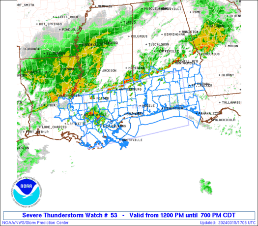
Severe Thunderstorm Watch Number 53
NWS Storm Prediction Center Norman OK
1200 PM CDT Fri Mar 15 2024
The NWS Storm Prediction Center has issued a
* Severe Thunderstorm Watch for portions of
southern Alabama
western portions of the Florida Panhandle
southeastern Louisiana
southern Mississippi
Coastal Waters
* Effective this Friday afternoon and evening from NOON until 700
PM CDT.
* Primary threats include...
Scattered damaging wind gusts to 65 mph likely
Scattered large hail events to 1.5 inches in diameter possible
SUMMARY...Thunderstorms are expected to continue increasing in
coverage and intensity this afternoon, with stronger storms/bands
likely to produce damaging wind gusts and hail.
Storms will spread eastward/southeastward with time, weakening --
and gradually moving offshore -- by early evening.
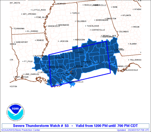
The severe thunderstorm watch area is approximately along and 80
statute miles north and south of a line from 50 miles north
northwest of Houma LA to 30 miles east of Crestview FL. For a
complete depiction of the watch see the associated watch outline
update (WOUS64 KWNS WOU3).
PRECAUTIONARY/PREPAREDNESS ACTIONS...
REMEMBER...A Severe Thunderstorm Watch means conditions are
favorable for severe thunderstorms in and close to the watch area.
Persons in these areas should be on the lookout for threatening
weather conditions and listen for later statements and possible
warnings. Severe thunderstorms can and occasionally do produce
tornadoes.
&&
OTHER WATCH INFORMATION...CONTINUE...WW 52...
AVIATION...A few severe thunderstorms with hail surface and aloft to
1.5 inches. Extreme turbulence and surface wind gusts to 55 knots. A
few cumulonimbi with maximum tops to 500. Mean storm motion vector
27035.
...Goss

   SEL3

   URGENT - IMMEDIATE BROADCAST REQUESTED
   Severe Thunderstorm Watch Number 53
   NWS Storm Prediction Center Norman OK
   1200 PM CDT Fri Mar 15 2024

   The NWS Storm Prediction Center has issued a

   * Severe Thunderstorm Watch for portions of
     southern Alabama
     western portions of the Florida Panhandle
     southeastern Louisiana
     southern Mississippi
     Coastal Waters

   * Effective this Friday afternoon and evening from NOON until 700
     PM CDT.

   * Primary threats include...
     Scattered damaging wind gusts to 65 mph likely
     Scattered large hail events to 1.5 inches in diameter possible

   SUMMARY...Thunderstorms are expected to continue increasing in
   coverage and intensity this afternoon, with stronger storms/bands
   likely to produce damaging wind gusts and hail.
   Storms will spread eastward/southeastward with time, weakening --
   and gradually moving offshore -- by early evening.

   The severe thunderstorm watch area is approximately along and 80
   statute miles north and south of a line from 50 miles north
   northwest of Houma LA to 30 miles east of Crestview FL. For a
   complete depiction of the watch see the associated watch outline
   update (WOUS64 KWNS WOU3).

   PRECAUTIONARY/PREPAREDNESS ACTIONS...

   REMEMBER...A Severe Thunderstorm Watch means conditions are
   favorable for severe thunderstorms in and close to the watch area.
   Persons in these areas should be on the lookout for threatening
   weather conditions and listen for later statements and possible
   warnings. Severe thunderstorms can and occasionally do produce
   tornadoes.

   &&

   OTHER WATCH INFORMATION...CONTINUE...WW 52...

   AVIATION...A few severe thunderstorms with hail surface and aloft to
   1.5 inches. Extreme turbulence and surface wind gusts to 55 knots. A
   few cumulonimbi with maximum tops to 500. Mean storm motion vector
   27035.

   ...Goss
Note:
The Aviation Watch (SAW) product is an approximation to the watch area.
The actual watch is depicted by the shaded areas.
   SAW3
   WW 53 SEVERE TSTM AL FL LA MS CW 151700Z - 160000Z
   AXIS..80 STATUTE MILES NORTH AND SOUTH OF LINE..
   50NNW HUM/HOUMA LA/ - 30E CEW/CRESTVIEW FL/
   ..AVIATION COORDS.. 70NM N/S /22SE BTR - 34E CEW/
   HAIL SURFACE AND ALOFT..1.5 INCHES. WIND GUSTS..55 KNOTS.
   MAX TOPS TO 500. MEAN STORM MOTION VECTOR 27035.

   LAT...LON 31409099 31948601 29628601 29089099

   THIS IS AN APPROXIMATION TO THE WATCH AREA.  FOR A
   COMPLETE DEPICTION OF THE WATCH SEE WOUS64 KWNS
   FOR WOU3.
Watch 53 Status Report Message has not been issued yet.
Note:
Click for Complete Product Text.
Tornadoes
| Probability of 2 or more tornadoes |
Low (10%)
|
| Probability of 1 or more strong (EF2-EF5) tornadoes |
Low (
|
Wind
| Probability of 10 or more severe wind events |
Mod (60%)
|
| Probability of 1 or more wind events > 65 knots |
Low (20%)
|
Hail
| Probability of 10 or more severe hail events |
Mod (40%)
|
| Probability of 1 or more hailstones > 2 inches |
Low (20%)
|
Combined Severe Hail/Wind
| Probability of 6 or more combined severe hail/wind events |
High (90%)
|
For each watch, probabilities for particular events inside the watch
(listed above in each table) are determined by the issuing forecaster.
The “Low” category contains probability values ranging from less than 2%
to 20% (EF2-EF5 tornadoes), less than 5% to 20% (all other probabilities),
“Moderate” from 30% to 60%, and “High” from 70% to greater than 95%.
High values are bolded and lighter in color to provide awareness of
an increased threat for a particular event.
[ad_2]