[ad_1]
No enough data for Intensity/Distance curve
For more information on computation, see the article Bossu et al., 2016:
- Thumbnail Based Questionnaires for the Rapid and Efficient Collection of Macroseismic Data from Global Earthquakes, Rémy Bossu, Matthieu Landès, Fréderic Roussel, Robert Steed, Gilles Mazet-Roux, Stacey S. Martin, and Susan Hough. Seismological Research Letter. Oct 2016. doi: 10.1785/0220160120;
- Furthermore, to avoid the association with wrong events, we filter testimonies in distance and in intensity depending on the magnitude of the seismic event.
References for tectonic plate boundaries:
Coffin, M.F., Gahagan, L.M., and Lawver, L.A., 1998, Present-day Plate Boundary Digital Data Compilation. University of Texas Institute for Geophysics Technical Report No. 174, pp. 5.
Maps view: Seismicity from the previous 7 days in the area  . . |
|
 Regional instrumental seismicity
This seismicity maps have been generated by concatenating the ISC catalogue (since 1964), the EMSC Euro-Med Bulletin catalogue and the EMSC Real Time catalogue. Therefore, they show the seismicity from 1964 until the earthquake occurrence.
Regional deadly earthquakes from 1500 to origin time
| Date | Long. | Lat. | Mag. | Death | Location |
| 1407-04-00 | 36.0 | 36.0 | ? | 100 | TURKEY-SYRIA BORDER REGION |
| 1408-12-29 | 36.2 | 36.5 | 7.3 | many | TURKEY-SYRIA BORDER REGION |
| 1668-09-13 | 32.6 | 37.9 | ? | many | CENTRAL TURKEY |
| 1752-07-21 | 35.5 | 35.5 | 7.0 | 20000 | NEAR THE COAST OF SYRIA |
| 1796-04-26 | 36.0 | 35.7 | 6.6 | 1500 | SYRIA |
| 1835-08-23 | 35.5 | 38.5 | ? | 300 | CENTRAL TURKEY |
| 1872-04-03 | 36.5 | 36.4 | 7.2 | 1800 | TURKEY-SYRIA BORDER REGION |
| 1940-02-21 | 35.5 | 38.4 | 5.2 | 37 | CENTRAL TURKEY |
| 1945-03-20 | 35.8 | 37.4 | 5.7 | 300 | CENTRAL TURKEY |
| 1956-03-16 | 35.5 | 35.6 | 6.0 | 148 | NEAR THE COAST OF SYRIA |
| 1998-06-27 | 35.3 | 36.9 | 6.2 | 145 | CENTRAL TURKEY |
Source:
|
|
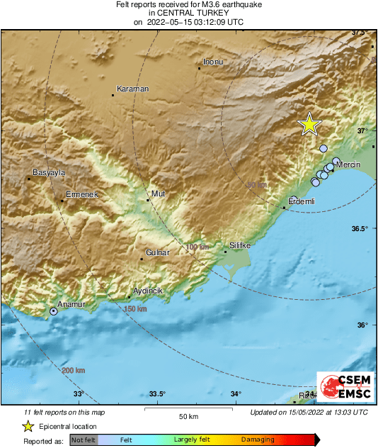
Map created with the testimonies provided by the eyewitnesses (click to enlarge).
|
|
[ad_2]